


This post is the latest in the Drones and Small Unmanned Aerial Systems Special Series, which profiles interesting information, thoughts and research into using drones, UAVs or remotely piloted vehicles for journalism and photography, that Kike learns about during his travels.
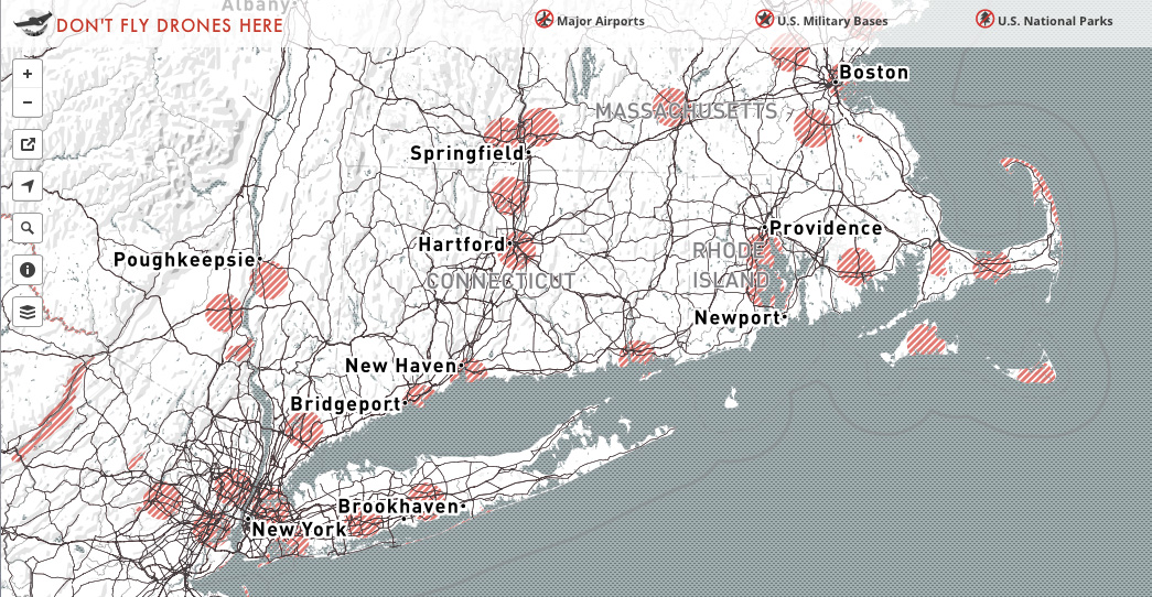
I believe this map of the United States created by Mapbox will become a very useful tool to all Small Unmanned Aerial Vehicle pilots. It includes no-fly zones implemented by states, cities and other national organizations while the FAA announces its own rules and regulations. The map displays major airports, US Military Bases, US National Parks and Temporary Flight Restrictions. It allows users the possibility of adding a source to the map. You can add a source to the map and to submit your feedback.

Follow Kike Calvo on Facebook, Twitter, Web, Tumblr, LinkedIn or Instagram.


Learn More About Drones:
Kike Calvo´s Drone Collections

Drone / UAV Dictionary: Includes 300 Commercial UAV Applications
Drones: Their Many Civilian Uses and the U.S. Laws Surrounding Them.
Cool stuff for Drone and Unmanned Vehicle enthusiasts
Drone Entrepreneurship: 30 Businesses You Can Start
Small Unmanned Aircraft: Theory and Practice
Introduction to Unmanned Systems: Air, Ground, Sea & Space
UAV Fundamentals Executive Course
How to Start an Unmanned Aircraft Vehicle (UAV) Business Course on DVD
Introduction to Unmanned Aircraft Systems
Fly by Wire Aircraft: Fighters, Drones, and Airliners
Introduction to Remote Sensing, Fifth Edition
Popular minicopters and drones include:
DJI Phantom 2 Quadcopter with Zenmuse H3-3D 3-Axis Gimbal
3d Robotics Iris+ Multicopter 915 Mhz 3DR IRIS+
Parrot AR.Drone 2.0 Elite Edition Jungle
Parrot MiniDrone Rolling Spider
MaxSale Hubsan X4 H107C 2.4G 4CH RC Quadcopter With Camera Mode 2 RTF